

Dedicated to
St. Sergius of Radonezh
“A Plan of the Road of the World & Peace”
website
of Alexey Smirnov
*
*
*
*
*
*
*
*
*
*
*
*
*
*
*
*
*
*
*
*
*
*
*
Alexey B. Smirnov
A.B. Smirnov, the analyst & truth-seeker
*
*
*
*
*
*
*
*
*
*
*
*
*
*
*
*
*
*
*
*
*
*
*
“A Plan of the Road of the World & Peace”
the connection between Asia and North America
a passageway across Bering Strait
Foreword
The title of the article «План Путь Мира», which was introduced by the author in Russian, contains double meaning, since Russian word «мир» has two significations. First meaning is “the world”, and second meaning is “peace”. Hence, the title of the article in English is: “A Plan of the Road of the World” plus “The Plan of the Road of Peace”, or just “The Plan of the Road of the World & Peace”.
Introduction
Engineering experts from some countries maintain that the current technology used for bridge building and railway construction has already reached a level where it’s possible to build a road linking China to the United States, overcoming all natural obstacles on the way, including Bering Strait. Modern engineering is able to encompass all kinds of environmental factors including hurricanes, extreme cold, and high levels of seismicity, ice, raging rivers and unpredictable tides.
There are a number of technical developmental works on this issue, which can be found in the media and on youtube.com. Despite the fact that it is feasible from the engineering point of view those projects lack economic reality. I therefore will pay attention below to this highly important aspect of any project of connection between Asia and North America.
There are a number of technical developmental works on this issue, which can be found in the media and on youtube.com. Despite the fact that it is feasible from the engineering point of view those projects lack economic reality. I therefore will pay attention below to this highly important aspect of any project of connection between Asia and North America.
Today there is no need to prove the necessity of the construction of a railroad to connect Asia to North America. This trunk-railway involves crossing Bering Strait. The land connection between the two continents would contribute to world trade. It would also be of use in the global division of labour since the current production of high-efficiency machinery is based on the application of necessary modules, assemblies and parts and components being produced in different countries of the world. These are located on different continents and the number of countries involved in world division of labour continues to grow.
The joining of the continents of Eurasia and America could become an important step toward a world without war. It would have great significance for the future of our planet. If cultural globalisation tries to impose mankind to uniform standards of thinking and behaviour and provokes conflicts around the world, globalisation in trade, economic and industrial spheres brings businesses, countries and peoples together. Co-operation on a material level helps us to overcome our differences. People gradually come to the realisation that we share the earth with each other, as well as other inhabitants such as animals and plants.
The third factor in favour of this project is that it is economically beneficial to several countries. An understanding of the common good helps to overcome political differences.
It is necessary to underline that, despite its public and political importance, a trunk-railway between Asia and North America in normal situations has to be profitable to its investors. The point of profitability of the project becomes even more important because it allows opportunity to continue construction of the trunk-way from both its ends to make a worldwide road.
I would like to point out to potential investors and politicians that the current low exchange rate of the rouble allows the carrying out of the project with minimal cost. It is hard to imagine a better time to implement it than now. This is significant due to the fact that the largest part of the trunk-way between Asia and North America is in Russian Territory, and the Bering Strait link is created between Russia and USA.
There is no design or technological idea that can reduce construction expense so much as the low labour cost in Russia now caused by the current exchange rate. This rate may not be sustained for long and should the rate of the rouble rise the whole project would cost significantly more. If this opportunity is missed the whole project would need to be postponed until “better times”.
1.
We have to consider the project as an investment as well as serving its purpose for cargo and passenger transport.
On one hand, the project at a cost of approximately $100Bn for the construction of the trunk-way may not be profitable by laying one thread of the railroad only. I imply a full railway with two tracks in each direction, as the thread. It would be difficult to make a profit even with two threads completed, although it might be possible by increasing the speed of trains and reducing time intervals between them.
On the other hand, at least two threads to transport goods between China and the US would be required. This takes into consideration the high intensity and the speed of trains. This assessment is based on an analysis of both Siberian railways that currently transport goods between China and Europe. Meanwhile China also uses land transport which travel through Kazakhstan (the European part of Russia). Cargo ships are also currently used. The volume of trade between China and the US is far higher than with European countries.
At the same time it would be economically expedient to join Japan to the main trunk-way. Even if this opportunity were to be delayed it should be taken into account while planning the route from Asia to North America. Thus the finished project should include the laying of three or four threads. No doubt this will make the project more attractive to investors.
The passageway should not be limited by the connection of two points in Asia (one of which is located on the Russian-Chinese border and the other on the Russian-Japanese) with a point in North America. To make the project profitable, we should envisage further deliveries of goods to the territories of the United States, Canada, China, Russia and Japan. This is the task ahead for creators of this project.
There is a particular part within the whole task. This is the connection of above mentioned two points in Asia with the point in America. That particular task starts with crossing the widest river Amur (Heilongjiang). The village Pashkovo in the Jewish Autonomous oblast, which is located near the Amurskaya oblast could become the starting point of the trunk-way. This place is convenient because it’s situated about 20 kms from both the Trans Siberian railway and the highway. There is an official crossing of the Russian-Chinese border in Pashkovo. Pashkovo is suitable as a starting point because it is also a convenient place to create a hydroelectric dam on the Amur River. In addition to generating power, the HPP would solve the problem of flooding beneath the Amur. The dam could be used as a support for an overpass for the trunk-way as well as a highway. Otherwise a convenient place for the construction of a bridge is located near the village Pashkovo: either above or below the river. At the other end of the trunk-way there is a hamlet, Duffield, in Alberta, Canada with two highways and one railway passing through it.
In addition to the main trunk-way project there are three more tasks:
1) A rail to connect Japan to the trunk-way
2) A railroad to the south of China
3) On the eastern side there are two types of rail that could go south from Duffield. The trunk-way with a track gauge of 1435mm has to be connected with the existing railway networks of Canada and the US, which have the same gauge. A double-line railway with a Russian gauge of 1524 mm could cross the Canadian- American border and then cross American territory to the border with Mexico. The reason for laying the Russian gauge on the American Continent is explained below.
The splitting of the task into one main and three sub-projects allows an invitation of investors for each of these projects. It should not be forgotten that the main project cannot be cost effective without the implementation of the three additional ones, and vice versa – additional projects are meaningless without crossing Bering Strait. The inclusion of investors for the additional projects should be finalised before construction of the main trunk-way begins. However, the additional project work should be started after the main construction has begun.
This article is primarily devoted to the main project, which includes the trunk-way and the passage. I call the project of the connection between Pashkovo, Russia and Duffield, Canada “the Joining”, and the project of the crossing of Bering Strait, “the Linkage”.
2.
In the previous chapter we mentioned the necessity of constructing a Bering Strait passageway with at least 3 – 4 threads; a thread means a double tracked railway. However, most likely that number of tracks will not satisfy the entire demand for railway services. Given the fact that today’s freight from China and Japan to the US surpasses traffic in the opposite direction, it would be reasonable to make provision for nine tracks for the Linkage portion. To this number at least two lanes for road transport need to be added. Since the text is written, the final decision of designers is determined by this multiple-line strait link.
Depending on the selected route length, the Linkage section would be 90 – 100 km. The maximum depth of the strait is 91 metres. The average depth in a straight line between Cape Dezhnev and Cape Prince of Wales is about 50 metres, not taking into account the narrow and shallow coastal zones on both sides of Bering Strait and around the two Diomede Islands, located almost in the centre of the strait. More specifically the islands are slightly closer to the Alaskan shore. The distance between these islands is about 4 km: and the interval between them is almost as deep as the strait. The larger island belongs to Russia and the lesser to the US and between these islands there is a state boundary – the international date line. The International Date Line was invented in the 19th century; today it is a great obstacle for world trade and communications in the Pacific Ocean area. This disadvantage can be overcome. I wrote previously in the article “The Planetary Time” – how it could be done (this article is in Russian). There is also an opportunity to follow the lower depths in the strait - however, this would increase the length of the passageway. With a tunnel option the length of the Linkage portion would be 130 km.
Besides the obvious inconveniences of the extreme north, bridges crossing Bering Strait would be exposed to heavy ice blocks as well as storm winds and typhoons. There are also mists, which according to some authors occur up to 300 days per year. It is well understood that when it’s foggy, the speed of traffic is significantly lower.
The construction and operating of the Linkage will be in an area of high seismic activity, in such conditions and with such a great length, it would be too risky to use underground tunnels – as a number of tunnels would be required, and therefore higher risk of damage. There would need five tunnels even with two tracks inside each tunnel.
A tunnel on the sea bed of Bering Strait in its full width would be difficult to complete because of uneven and hard rocky ground. There would also be a problem with ventilation caused by the huge length of the tunnel sections.
On analysis of the information a conclusion is reached on the appropriateness of using a dam for the crossing of Bering Strait. There should actually be two dams to provide navigation between the Russian and American Islands. The first dam would connect Cape Dezhnev with Ratmanov Island (Big Diomede Island) and the second would link the Cape of Wales with Little Diomede Island (Krusenstern Island). In addition, a bridge needs to be constructed or a short underwater tunnel between these two dams. The dam itself should be manufactured from reinforced concrete and have a hollow stepped structure. Three levels would be needed for trains and vehicles within the dam, which are placed below sea level. One further level would be above water level. This level would be narrower than the others, but higher and with the option to accommodate an extra railway as well as a lane for vehicles of extra height.
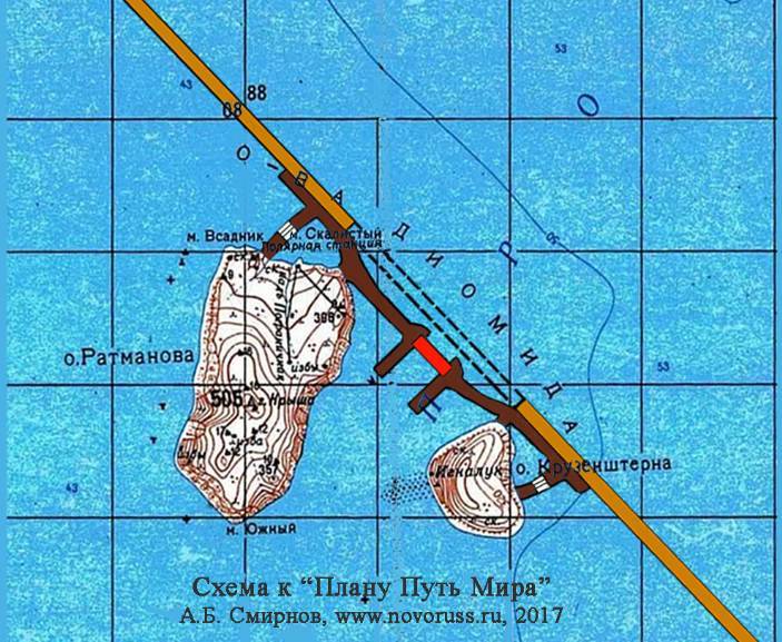
The scheme of the strait link near Diomede Islands
In the area between the two Diomede Islands, where ships will navigate – as per schematic – the two lower levels of both dams marked in an olive colour, are connected by underwater tunnels, shown with two dashed lines. One hollow dam comes from the Russian shore of the former village Naukan and the other goes to the American shore at a point located slightly northward from Wales Airport.
Aside from the hollow dams, two moles would be constructed in shallow water. Each mole adjoins its own dam and there would be a bridge between the two moles. The moles are painted brown and the bridge is shown in a reddish colour. The design of each mole allows getting transport from the two upper levels of each hollow dam, and the bridge connects two those moles. Additionally, each mole forms a dry dock as well as a port for ships. While referring to the dams, moles, ports, and dry docks on Diomede Islands as well as the other structural elements of projects, both the Joining and the Linkage, it makes sense to add W (west) or E (east) – W corresponding to the Russian side and E to the US & Canadian side. Any projects with regard to territories of China, Japan and Russia use the letter W but Canada and USA – the letter E.
Two ports and two docks are needed because of the large volume of work to construct the passage in Bering Strait. Work at the Diomede Islands should start with the construction of ports, moles, and the power plant etc. It makes reasonable sense to begin the construction of the passage at Cape Dezhnev, together with other works on the Russian coast. Firstly, two ports should be created.
All structural elements for the Linkage are fabricated at dry docks. Because of the big volume of works, besides two docks on Diomede Island, similar docks should be created at both shores of Bering Strait.
The hollow dams with the underwater tunnel between them are set on a wide support, which extends throughout the strait. A bridge structure acts as such support, it plays the role of foundation for transport structures. The top part of the “bridge” fastened to metal columns of different heights, which are placed in two rows, and mounted on specially prepared places of rocky sea bed. The different height of the columns allows evening upper surface of that long support. Unlike a conventional bridge, its surface, being even, is not flat, as it has a form of a grid with extra large cells. It is obviously, all metal structures are protected from corrosion. Design of the support has to prevent oscillations of the dams and the underwater tunnel to be installed on it, as well as their floating.
Construction of the transport corridor of Bering link should start from the middle of the strait. At first the underwater tunnel is mounted, and then transitional blocks joined to the tunnel from both sides. These blocks connect the tunnel with two lower levels of the hollow dams. Following this, mounting of both two dams begin in the direction of the appropriate shores.
Both dams have the same design, and consist of, mainly, the same standard elements of two sorts. One kind of blocks provides traffic along two lower levels of the hollow dams, and another kind is designed for two higher levels of the dams. As mentioned above, its upper part is located above the water level.
For protection of the dams from ship collisions, there are created sea zones with the navigation bad there. Four such zones locate nearby both sides of two dams. There will be organised graveyards of ships. It is advisable protecting of the dams with American and Russian coast guards (each of them keeps the zones in own maritime area) and using anti-ship mines, during the period the graveyards to be creating.
In the area where the sea is ice-covered or ice can be expected for about 8 months of the year (traffic is rare outside this time) it would be sufficient to build the bridge 800 feet long (243.84 metres) with a height span of 100 feet (30.48 metres). An arched concrete bridge which requires less attention and expense in the period of its use is recommended here.
The design of the passage proposed here, allows piecemeal construction of the Linkage. During the first period both hollow dams and the underwater tunnel could be constructed. In this case the train and vehicle traffic on the two lower levels could begin immediately. The second part of the strait link would consist of constructing the parallel bridge and then traffic on the two upper levels could begin.
3.
On the basis of the plan in the previous chapter, it would be reasonable to divide the strait link into two stages.
For the first stage, as is practised in the construction of railways, it would be necessary to lay an auxiliary road as well as a three track railroad beginning from the village Pashkovo (on the Amur river to Naukan) at Cape Dezhnev. Likewise to connect a three track railroad from Duffield, Alberta at the point where the dam E sits on the Alaskan shore. (I use the name of the nearest settlement, which is Wales) Both segments of the three-track railway should be constructed with the track gauge of 1435 mm which is used in China, Canada and the US. This track gauge provides a quick attachment at both ends of the railway network of China, Canada, the US respectively, within the framework of the two additional projects. As mentioned above, these two projects could have their own investors, but their completion has to be synchronised with the ending of the trunk-line Pashkovo to Duffield so all those projects can begin to generate income. It becomes clear from information given earlier that the three-track railroad is reserved for future freight traffic between these countries. As you will see shortly, two railways with a track of 1524 mm will be constructed within the first stage.
At the same time as the trunk-line construction, a passage from China across the Amur River should be built. Besides the construction of a multi-lane bridge near Pashkovo, there is an alternative design of an overpass for a railroad and highway based on a hydroelectric dam. However, for this to happen an HPP would need to be erected.
Construction of the railroad with the Russian gauge 1524 mm would start from the moment the auxiliary road reaches the village Oudskie, Khabarovskiy Krai. Eventually there will be four railroads from this point in all directions, in accordance with the Russian standard. With regard to the railway to be designed westward I will cover that in the next chapter. Within the framework of the Strait link project, a double track northward to Duffield should be constructed and a single track southward built to intersect with the Trans Siberian Railway. There would be a 1524 mm, 20 km, double track railway from this intersection to Pashkovo and further on to China. In the framework already mentioned for additional projects there would be a 1524 mm double tracked railway from Duffield, through Canada and the US to the Mexican border. The same 1524 mm double track rail would cross China to the border with Vietnam. Instead of constructing new roads and a 1524 mm track in Canadian, American and Chinese territories there would simply be a refurbishment of 1435 mm tracks to 1524 mm of little used tracks that already exist there. Nowadays many railroads are not in use at all as a result of the development of road transport. In the future, railroads throughout the world might be used as passenger trains as well as cargo since their width might provide more comfort for passenger travel. So train travellers from America or China may travel to Europe now that the European Union is thinking about to link the Russian gauge to Paris.
Of the four railroads that start in Oudskoie, the first to be built should be a single track rail and a road to Nikolaevsk-on-Amur. This is both a river and a sea port. A plant should be created here where large reservoirs would be filled with compressed gas to meet the needs of the objects of the Russian segment of the joining. For the additional project to link Japan with the trunk-line of Asia to North America, two crossings are planned. One across La Perouse Strait is located between the Japanese Island of Hokkaido and the Russian Island Sakhalin with a length of about 45 km and the other three times shorter. The passageway between Sakhalin and Nikolaevsk-on-Amur should be constructed by Russia and the Russian government is already planning to do this. During construction of these two crossings there should be a double tracked railway along Sakhalin Island and a second track from Nikolaevsk-on-Amur to Oudskoie. Most likely all the works between La Perouse Strait and Oudskoie will be provided by Russia herself as it is needed for internal links.
It would be advisable to continue the 1524 mm railroad into Japanese Hokkaido and possibly to the central part of Japan. In this case, goods and passengers from Japan could travel to America and Europe without transhipment. Cargo would then also be delivered between North America, Europe and China without transhipment.
4.
Hence, it is proposed to construct five railway lines at the first part of the joining; three of them to have the gauge 1435 mm and two 1524 mm. The proposal includes a dual lane road for vehicles. The lower, or first level of the hollow dams to cross Bering Strait, carries three railroads and one lane of the highway. There would be two railroads on the second level of the dams as well as another lane of the highway. The lowest, or zero level of the dams which is placed on the rocky bottom of the strait is intended for alignment of transport levels.
The highest or fourth level of the dams is located above sea level. There is one railway and a one lane road here. Depending on customer requirements a third level could accommodate two or three railways. These rails should lead to Oudskoie. Possibly a further 1435 mm rail line should run southward from the village and it will be necessary to lay a double tracked 1524 mm railway in the direction of Europe. Obviously, an auxiliary road for vehicles will be needed here.
Those who draw a connection between North America and Asia on large scale maps may not realise that the path would be through mountains and large Siberian rivers (flowing from south to north) gradually expanding on their way to the Arctic Ocean. A railroad from Oudskoie towards Europe might be placed over the town Neryungri, to cross the Lena River at its riverhead and skirting the potent Angara River. There is only one mighty river along this route – the Yenisei. The Ob River is not wide in the town Kolpashkevo area. It would be best to cross the Ural ridge near Tyoplaya Gora, and then link to the Trans Siberian railway at Kungur station, which is located between Perm city and Yekaterinburg city. The village Oudskoie is also a good choice due to the plan to bring the railway from Japan to this point. Then, cargo and passengers could move by land between Europe and Japan using the shortest route to date.
Conclusion
The proposed project called the Joining differs from other projects by its economic realism. This project may become cost effective after completion of the first stage.
With the availability of sufficient investment funds, or even with their abundance available in the today’s world, the project of the Joining has great importance. It is the vastest made to date and provides the opportunity of obtaining a high and stable long term income. There is huge potential for development as a business project.
Finally, this project offers a central theme to the New Epoch now begun. The creation of such structures may advance humanity in its spiritual evolution. It is a movement toward a world without war in which nations, peoples, cultures, and the everyday man aspire to co-operate. The trunk line from Asia to North America is a powerful symbol of such co-operation.
Edited by Jenny Neve
The author of the project: Alexey Borisovich Smirnov
The Analyst and Seeker of Truth
11 August 2017
Marks: Alexey Smirnov, Bering Strait, Diomede Islands, the crossing over Bering Strait, China, USA, Canada, Japan, Russia, railway, the passage across Bering Strait, the strait link
© Alexey Borisovich Smirnov, 2021
novoruss.ru@gmail.com or elenalexey.smirnov@gmail.com
novoruss.ru@gmail.com or elenalexey.smirnov@gmail.com